Emergency Mangement
Mission Statement
To maintain an Emergency Services system as defined in ORS 401, by planning, preparing and providing for the prevention, mitigation and/or management of emergencies or disasters that present a threat to the lives and property of the citizens of Tillamook County.
Tillamook County Road Closure Updated
Join the Oregon Department of Emergency Management (OEM) and the Tillamook Emergency Volunteer Corps as we present Tsunami 101

Wednesday, April 1
5:30 PM to 7:00 PM
Tillamook County Library
1716 3rd St, Tillamook
Don't Miss This: Tsunami 101 Roadshow
Living on the Oregon Coast means living with the reality of tsunami risk. Whether you've been here for decades or just a few years, there's always more to know — and this free community event is one of the best opportunities we've seen to get informed and get prepared.
Regional experts are coming to the City of Tillamook to share life-saving information on what to do before, during, and after a major seismic event. You'll leave with a clear understanding of what those alerts, watches, and warnings actually mean, and — most importantly — what actions to take when they're issued.
You'll also learn about Assembly Areas — the designated gathering locations in our region where community members can go during an emergency. Where are they? What are they designed for? What will be available there? This presentation will answer all of that
Before you come, download the NVS Tsunami App.

The Oregon Department of Geology and Mineral Industries has developed a free app (Apple and Android) that shows you at a glance whether you're in a tsunami evacuation zone — and maps your safest route to higher ground, wherever you are in the county. Presenters will walk through the app during the session, so download it ahead of time and come ready to explore it together.
This is a rare opportunity to hear directly from the experts who study and plan for these events every day. We hope to see you there.
For those in north county area please plan on attending the Tsunami 101 in Manzanita

Everything YOU Need to Know About Tsunami’s and Earthquakes - Tsunami 101
Join the Oregon Department of Emergency Management (OEM) and the Emergency Volunteer Corps of Nehalem Bay as we present Tsunami 101
Tuesday, March 31
3:30 AM to 5:00 PM
Pine Grove Community House
225 Laneda Avenue, Manzanita


|


Tsunami Evacuation Drill with the Great Oregon Shakeout on October 15, 2026 AT 10:15 AM this year.
What You Can Do to Stay Safe and Prepared:
- Know your evacuation routes: Whether you’re at home, work, or visiting the coast, familiarize yourself with local tsunami evacuation routes. Maps are often posted in coastal areas or can be found online using the DOGAMI/NANOOS Tsunami Evacuation Zones portal.
- Sign up for emergency alerts: Stay informed by subscribing to alerts at ORalert.gov for emergency notifications tied to your zip code—including earthquake and tsunami alerts. And turn on the Wireless Emergency Alerts (WEA) on your phone, so you will receive alerts based on where your phone is located (important if you are visiting the coast).
- Create a go kit: Prepare a portable emergency kit with essentials such as food, water, medications, and personal documents.
- Review your emergency plan: Ensure everyone in your household knows what to do during an earthquake or tsunami, including where to meet and how to communicate if separated. You can learn more about emergency planning with the free Be2WeeksReady Toolkit.
For Travelers:
• Check Travel Conditions: If traveling, visit www.tripcheck.com for real-time road conditions in Oregon.
• Neighboring States: If your travel extends to California or Washington, check their Department of Transportation websites for updates:
Travel | Caltrans, Travel Center Map | WSDOT.
DOGAMI encourages coastal residents and visitors to use this event as a reminder to stay informed about tsunami hazards and to practice evacuation drills regularly. DOGAMI provides additional information about tsunami preparedness at the Oregon Tsunami Clearinghouse OPRD recommends exploring Oregon’s beautiful coast safely by always being prepared for emergencies.
For more information about earthquake and tsunami preparation, visit Tsunami Safety.
If you do not have ShakeAlert on your phones, I suggest that you check out it out.
- The MyShakeTM app was developed by the UC Berkeley and is sponsored by the California Governor’s Office of Emergency Services. MyShake is available for free in the Apple iTunes and Google Play stores – more information is available here. MyShake is currently operating in California, Oregon, and Washington.
How do I sign up for the ShakeAlert® Earthquake Early Warning System?
|
MyShakeTM |
Mobile App |
Apple Store and Google Play |
MyShake For CA/ORWA |
CA/OR/WA |
Hopefully this information will help you become better prepared, please pass along to all you know that live along the west coast.
BE PREPARDED NOT SCARED
Emergency Alert Notifications
Sign up to be alerted about emergencies
On the Road

Make sure your vehicle is in good working condition before you travel.
Keep your gas tank as full as you can. A full tank will also keep the fuel line from freezing.
Install good winter tires and make sure they have enough tread, or any chains or studs required in your local area.
When driving, increase your following distance from 3-4 seconds to 5-6 seconds. It takes longer to slow down and stop on icy roads.
Every vehicle should have an emergency supply kit in the trunk. Kits should be checked every six months and expired items should be replaced regularly.
Keep family and emergency phone numbers, including your auto insurance provider and a towing company in your phone.
Consider keeping a power bank for your phone in your car in case your car loses power.
If stranded, run the engine for about 10 minutes per hour to run the heater and charge your cellphone. Open a window slightly to let fresh air in and avoid carbon monoxide (CO) poisoning.
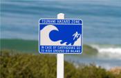
TSUNAMI & HAZARD AREA MAPS
|
|